Canvas Fun 2 - Map Lines
 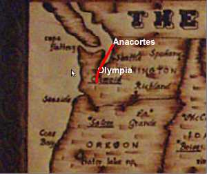
Here are some further adventures with HTML canvas. For this one, I was trying to recreate an Indiana Jones style map to give someone a brief overview of my travels. Again, I realize this is by no means groundbreaking in terms of its display or anything, but the fact it is all done through HTML gets me pretty excited. Anyway, have a look and tell me what you think. Version #1, version #2 (As for the last adventure with canvas, I think I've isolated some of the issues, so hopefully it should load up correctly now. So go ahead and give it another look too, if you like. ) |
| Wednesday November 24 2010 | File under: coding, travel |
| Toggle Comments (4) | comment? |
| on Wed 24th Nov, 2010 11:44 pm PST Mom said: Yikes, Version #2 gave me motion sickness and, I might be wrong on this, but you aren't still in D.C. are you? ************************ on Fri 26th Nov, 2010 04:24 am PST Horge said: Nice. I'd like to see this kind of a thing for all your travels in the US and abroad going back however far you want. And extra cool bonus points if you can show us the mode of travel with some GIF sprite or something (plane/bus/Scoot-Scoot at the leading point of the line)? Or how about a timescale letting us know when such and such trip happened. Just a few requests from the peanut gallery! ************************ on Tue 30th Nov, 2010 10:15 pm PST joey said: Wren, hope all is well. Where did you get this map feature? it is really cool and I would like ot use it ************************ on Tue 30th Nov, 2010 10:18 pm PST Wren said: @Joey: I made it (both of them actually). Well, I stole the background images, of course, but I did all the coding myself. You are more than welcome to use it. Hit me up e-mail if you want to learn how to modify it to your liking. ************************ |
| <<FC 122 - Oh the Convenience | The Height Wall>> |
Recent Comments:
*Horge on Mother Wrenger in the Nutcracker
*Horge on A Whirlwind Eclipse Adventure
*Andrew on A Whirlwind Eclipse Adventure
*Mom on A Whirlwind Eclipse Adventure
*Mom on Mother Wrenger in the Nutcracker
Recent Content:
*A Whirlwind Eclipse Adventure
*Mother Wrenger in the Nutcracker
*Malta Bene!
*2023 Performance Review
*Twas the Night 2023
*Recycled Plastic Christmas Ornaments
*Halloween Act 2023 - Dueling Banjos
*Walk Like MADD 2023
*New Stilting Costume
*Sleeping Around 2022-2023
*Project Hotdog Halfway Complete
*Giant Juggling Club
Websites du Friends:
* Wren the Juggler
My I-guess-I'm-a-Professional-Juggler juggling website
* Wren and Della
Della and my juggling website
* The Real Food Show
A circus-inspired elementary assembly show to teach kids about healthy eating
* Della Moustachella
Della's performance website
* The Fun Bags
Della and Sadye's Performance Troupe
Tags
Anacortes (39)
Cambodia (5)
China (14)
Korea (1)
Macau (1)
Mexico (13)
New Zealand (1)
Seattle (2)
Thailand (18)
USA (11)
Vietnam (5)
beard (5)
blog (8)
books (1)
coding (15)
comic (45)
contest (4)
environment (9)
events (12)
food (22)
games (15)
geocaching (4)
holidays (13)
juggling (8)
links (9)
meet-ups (1)
mexico (1)
misc (54)
movies (5)
open letter (2)
participation (1)
pics (39)
poetry (6)
poll (1)
quote (6)
road trip (25)
stats (1)
transportation (14)
travel (136)
video (6)
work (8)